The Cooch Behar State Railways (1903)
"The Cooch Behar state and its land revenue settlements" by H. N. Chaudhuri, Cooch Behar State Press, 1903.
Made available by the Internet Archive.
Link: http://www.archive.org/details/coochbeharstatei00chaurich
Source: Library Systems of the University of California
Selected and edited with comments by R Sivaramakrishnan. July 19, 2010.
The book is not merely about land revenue settlements. It is truly encyclopaedic, being a compendium of all topics related to the native state of Cooch Behar in the beginning of the 20th century. This voluminous text deals with the geography, the history, the people, their religions and culture, the economy and the administration of the state, besides interesting details about the State’s own railway.
Cooch Behar (Koch Bihar) was a 13-gun salute princely state with area of 1,307 sq. miles and a population of 567,000 in 1891, that lies on the Himalayan foothills to the south of the kingdom of Bhutan, west of the Brahmaputra valley of Assam and north-east of the Gangetic plain of Bengal. Cooch Behar is a low-lying plain, intersected by several rivers that rise in the Himalayas and flow generally SE, emptying into the Brahmaputra that flows just outside the state. A major tributary, the Teesta, skirts the state to its west and south-west. River Torsa flows just south of the capital, Cooch Behar town.
Maharaja Nripendra Narayan (1862 – 1911), known as the architect of modern Cooch Behar town, established Cooch Behar State Railway in 1893-98. Earlier, in 1876, East Bengal Railway had established the first station at Haldibari on the western edge of the State, on its trunk route to Siliguri via Jalpaiguri.
The State’s own 2’ 6” railway, was constructed in 1893, running north from Mughal Ghat just south of Gitaldaha, its junction with the Eastern Bengal State Railway, for a distance of 24 miles, stopping on the right bank of R. Torsa below the capital town of Cooch Behar. It was opened to passenger traffic on 1st March 1894. The river was then bridged, taking the line into the town; the line was extended up to Alipur on the Kaljani at the northern border of the state, then continued further north to Buxa and Jainti at the Himalayan foothills bordering Bhutan. Of CBSR’s total length of 53 ½ miles, 33 ½ miles lay within the State. It was operated by EBSR, and converted to metre gauge in 1910.
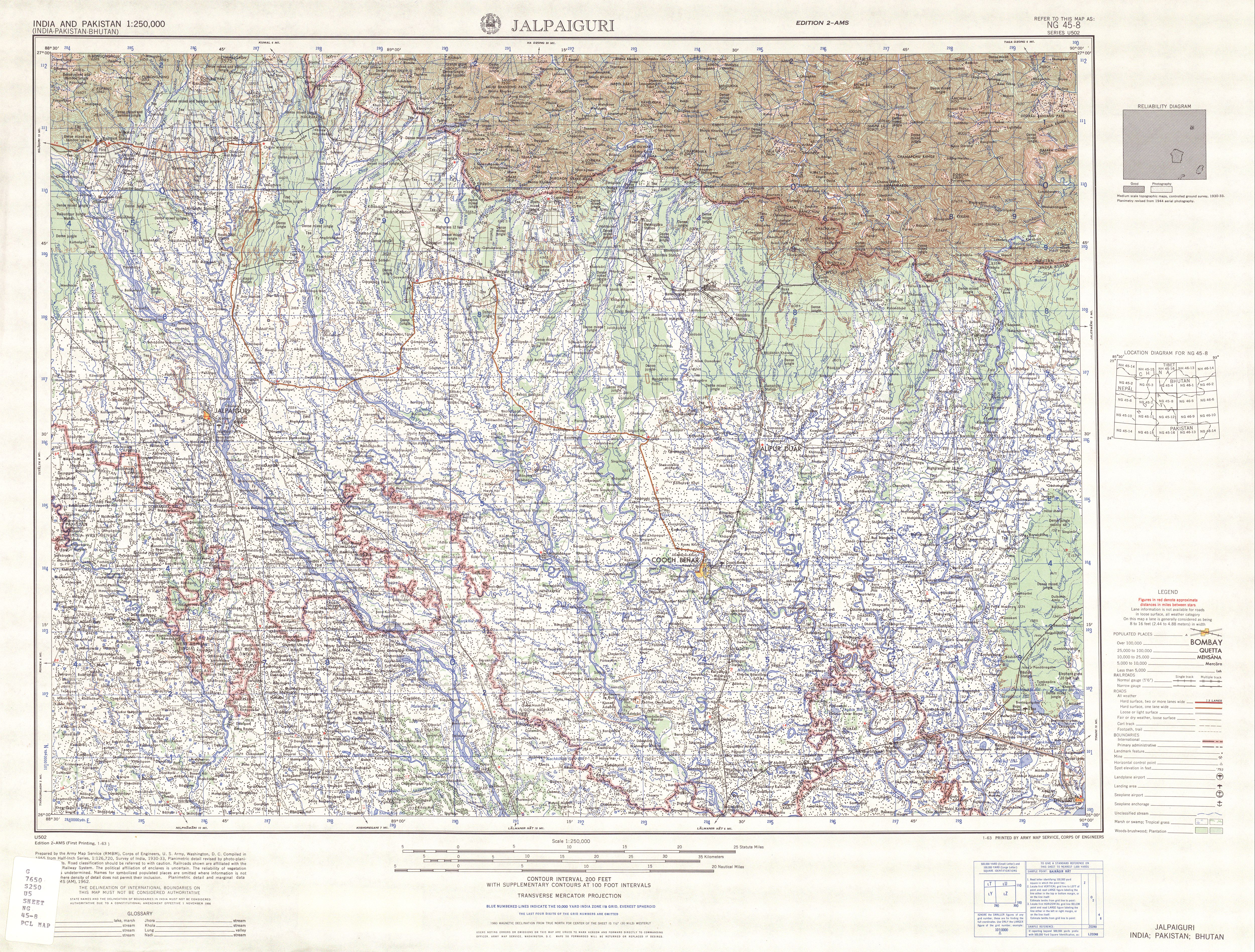
See the Jalpaiguri sheet of the AMS (1955) series of 1 : 250,000 topographic maps from the Perry-Castaneda collection in the University of Texas at Austin:
http://www.lib.utexas.edu/maps/ams/india/txu-oclc-6614190-ng45-8.jpg
Segments of other railways too passed through the territory of the native state; as of 1903, an extension of the Eastern Bengal State Railway from Mughal Hat to Dhubri ran through the southeast of the State for a distance of 12 miles, and on the west the northern section of the line ran for a distance of 5 ¾ miles. A short section (2 ¾ miles) of the Bengal - Duars Railway from Barnes Ghat to Lalmanir Hat also lay within the State.
W. W. Hunter, “Imperial Gazetteer of India”, Volume 10 (1903), p. 391 et seq.
http://dsal.uchicago.edu/reference/gazetteer/pager.html?objectid=DS405.1.I34_V10_391.gif
Cooch Behar acceded to and merged with India in 1949 and became a part of West Bengal. The vicissitudes of the partition wrecked havoc on the rail system linking India’s northeast with the rest of the country, requiring urgent construction of missing links and major realignments on the pre-Partition dispensation. A number of “New” stations were constructed to smoothen the new routes, freeing them of kinks and convolutions. But this was not as bewildering as another aftermath of the Partition, which left a maze of enclaves, including “enclaves within enclaves”. See “Indo-Bangladesh Enclaves” in Wikipedia, - http://en.wikipedia.org/wiki/Indo-Bangladesh_enclaves
Also,
http://strangemaps.files.wordpress.com/2007/05/coochbehar_annotated1.jpg
http://exclave.info/current/indo-bangla/map_btw_rangpur_&_cooch_bihar.jpg
Now the extract on the Cooch Behar State Railway from H. N. Chaudhury’s opus.
The want of easy communication with other parts of Bengal had been experienced for a long time. The proclamation issued by His Highness the Maharaja Bhup Bahadur to his subjects after his Installation was concluded with the following important announcement:
"Being anxious to connect our capital with the Railway svstem of Bengal we contemplate measures for the construction of a Railway to Gitaldaha."
The scheme of connecting Cooch Behar with the Railway by a line to Maghal Hat, the terminus of the Kaunia and Dhubri line, was first taken in hand in January 1883, when Major Engledue, the then chief Engineer of the Northern Bengal State Railway, inspected the line under the orders of Government, and an estimate for a 2 ½ feet gauge Railway over the existing road was prepared in his office and submitted to Government for sanction. In anticipation of sanction to the above estimate, an embankment from the Sunity bridge at the Kalighat on the Torsa to the corner of the Jail Road, as recommended by Major Engledue, was constructed. After the Installation His Highness in Council decided to have the work finished, and the earth-work in raising the old road was commenced.
After a good progress had been made Mr. Furnival, the Agent of the Bengal Central Railway, was asked to give his professional opinion on the scheme. On the report of this gentleman in January 1884 the idea of a narrow gauge Railway on the old road was abandoned, and it was decided that a metre gauge line on a new embankment should be made. The survey was accordingly commenced but never finished, as on a reconsideration of the whole question shortly after, the scheme was indefinitely postponed.
The difficulties which appeared to stand in the way of the construction of a railway to Cooch Behar were due to the probable uncertainty of the action of the British Government in regard to the Kaunia-Moghalhat branch, and the through line to Dhubri. After correspondence with the Bengal Government it was ascertained in 1890 that the Government had no intention of abandoning the line from Kaunia to Moghal Hat and was in favour of converting it to the metre-gauge. Thereupon the construction of a 2 ½ feet gauge railway from the south side of the Torsa opposite the town of Cooch Beliar to Dewanhat, and thence to Gitaldaha was decided upon in 1891-92. The line was surveyed and constructed under Mr. R. W. H. Warneford, c.E., It was completed and opened for goods traffic from the 15th September 1893, and for passenger traffic, from the 1st March 1894, with the following stations: - 1 Torsa, 2 Dewanhat, 3 Chawrahat, 4 Gitaldaha, 5 Gitaldaha Ghat.
Two more stations were opened in 1895-96, one at Bhetagnri and the other at Fakirtakiya. These are flag stations and lie at two important level-crossings of the line. Under an agreement between His Highness and the Government of India, the management of the line was placed for two years in the hands of the Manager of the Eastern Bengal State Railway. This arrangement proved advantageous to the State, as it ensured an economical management of the line, no charge for supervision, which is estimated at 12 ½ per cent., being made by the Government. Only a charge for the supervision and keeping of accounts, proportionate to the receipts and expenditure of the line, was made in the same ratio as the cost of the Examiner of Account's office bears to the receipts and expenditure on the Eastern Bengal State Railway.
From the beginning of 1896, when the old working arrangement ended, the line is being worked by the Manager, Eastern Bengal State Railway System, for 45 per cent of the earnings, the State getting 55 per cent as its share of the profit. On this arrangement the line paid 5 per cent on the capital outlay in 1896. On account of the threatened encroachment of the Torsa on a section of the line, a couple of miles down the Torsa station, the Railway was diverted to the east, and brought up in the town to the east of the jail in 1897-98. The town extension to the Cooch Behar station was opened for local booking for both coaching and goods traffic from the 15th December 1898, and for through-booking with foreign railways from the 1st January following.
The Torsa bridge was completed and opened for through running on the 15th June 1900. The extension of the railway to Kholta on the frontier of the State was taken in hand by the end of 1897-98, and opened with the bridge over the Kaljani as far as the Alipur Duar Station in the following year. Baneswar is the only station in the State on this section of the line.
The railway was afterwards extended to the right bank of the Jaintia river near the Bhutan boundary.
The total length of the line within the State is 35 miles.
The total capital outlay on the railway up to 31st March 1900 was Rs. 13,21,638, viz., Rs 10,82,638 on the portion from Gitaldaha to Cooch Behar town including the Torsa bridge, and Rs. 2,39,000 on the section between Cooch Behar and Alipur Duars. Of the total cost, eight lacs of rupees was taken as a loan from the Government of India, five lacs of which was received in 1892-93, and two lacs in 1897-98, on the security of the Chaklajat Estates.
The net earnings of the railway are improving every year as will appear from the following figures.
Year. Net earning.
1897-98 15,157
1898-99 23,451
1899-00 47,446
The book contains some goods maps of the State and the Town as in 1900, as well as a photographic image of the Cooch Behar railway station (between pages 328 and 329): the station was by no means spectacular – understandable as just two pairs of passenger trains ran on the line even as later as in November 1932, one in the morning and the other in the evening.